Truth and Consequences, then Roswell
About two hours from Flagstaff is the Petrified Forest National Park, which encompasses parts of the Rainbow Forest and the Painted Desert. While the names sound glorious, this park’s description may not sound appealing, as it comprises stone log fragments scattered over a remote and otherwise featureless section of the Arizona desert.
The Painted Desert is named for the rolling, multicolored landscape. The patterns visible in the eroded soft sedimentary rocks are due mainly to hematite (red), limonite (yellow), and gypsum (white), and the colors are especially striking at sunset.
200 million years ago, downed Conifer trees washed into a river and were buried quickly and deeply by sediment. This sealed them from oxygen and slowed their decay. Minerals replaced the log’s organic material and crystallized, forming amethyst, citrine, smoky quartz, and clear quartz. The resulting logs have rainbow hues and glitter in the sun.
In this area, scientists found many petroglyphs. Petroglyphs are rock carvings made by pecking directly on the rock surface. The lighter rock underneath is exposed when the dark “desert varnish” on the surface of a rock is removed. Newspaper Rock, a sandstone outcrop, bears 650 petroglyphs dating from around 1000-1300 AD. High concentrations of petroglyphs mark a place as hugely significant to the tribe.
Ancestral Puebloan people created the petroglyphs. They lived, farmed, and hunted along the Puerco River between 650 and 2,000 years ago. Modern American Indian interpretations of the drawings describe family or clan symbols, spiritual meanings, and calendar events. Some mark territory boundaries or migratory routes.
Most of the striking collections of logs are easily accessible from the road. Abby isn’t allowed on the trails. I hop out of the car, hike the short trail to the attraction, and hop back into the car before Abby even notices. Our last stop in the park is the Crystal Forest. Behind the Visitors Center is a 0.75-mile loop of concentrated shimmering logs. This section contains the largest log, at 10 feet in diameter and 35 feet in length. This log, named Old Faithful, weighs 44 tons. After I revere the tree with the appropriate respect and awe, Abby and I ramble on in search of lunch.
Between Flagstaff, Arizona, and Truth and Consequences, New Mexico is a blip on the map called Pietown, New Mexico. The town was a settlement since the 1920s, started by a man named Norman who opened a general store. He enjoyed baking pies- rolling his dough and making them from scratch. He served them to family and travelers. Mr. Norman’s pies were such a hit that everybody began calling the crossroads PieTown. In 1927, the locals petitioned for a post office. The authorities wanted a more conventional name. The PieTowners said it would be PieTown or no town. Now, the town is exactly what it sounds like, a “town” (more like an intersection) full of pie places and pies. It sits squarely on the Continental Divide, at 8,000 feet. It has 67 full-time residents and three pie shops. Pie Town is the location of the “Pie Festival” on the second Saturday of September, which I just missed.
The restaurant that is open when I pass through is called Pie-o-neer. The facade looks like an old west saloon, situate in the middle of the desert. The menu includes all the basics and Apple Cranberry Crumb, Starry Blueberry Night, Peachy Keen, Chocolate Chess with Red Chile, and Peach Green Chile. I try the blueberry pie, the pumpkin pie, and the coconut custard pie. All are delicious and gone in 10 minutes. I give a shout-out to my mom here because the pies were delicious, but not as good as hers. On my way out the door, I notice tie-dye shirts for sale. Across the chest is the peace symbol, the word “of”, and then the Pi (3.14) symbol. I smile and pull my car keys from my pocket.
High on sugar, peace(s of pie), and love, I head for Truth and Consequences. This town made it onto my map simply for its name and its hot springs. In March 1950, Ralph Edwards, the host of the popular NBC Radio program “Truth or Consequences”, announced that he would air the 10th anniversary celebration from the first town that renamed itself after the show. Originally named Hot Springs, the city officially changed its name to Truth and Consequences on March 31. The program broadcast there the following evening. Edwards visited the town each year for the next 50 years, and the event that ensues is called “Fiesta”. It includes a beauty contest, a parade, and a stage show.
Fittingly, a town formerly known as Hot Springs, is also famous for its hot springs. Riverbend Springs is the spring with the highest Google reviews, closest to the home where I was staying.
When I arrive, a woman behind the front desk gently asks if she can help me. She finds my reservation and departs to prepare my tub. The soothing background music helps me to drop my tense shoulders and shake off the staleness of the road.
My private tub has two side walls and a back wall with a locked door. The missing fourth wall opens to a view of the Rio Grande River and Turtle Mountain. My appointment is at 7 pm, perfectly timed for the sunset. The sun is just outside of my viewing square, but still creates a colorful sky. I experience one of the most magical moments of my life, serenely lounging in bubbling hot water, watching the huge full moon rise above the horizon.
The next day, Abby and I continue on our journey through New Mexico. I see many sites referencing outer space. I see signs for the Museum of Space History, which contains exhibitions ranging from Robert Goddard’s early rocket experiments near Roswell to a mock-up of the International Space Station. I pass The Very Large Array, which is one of the world’s premier astronomical radio observatories, with 27 radio antennae in a Y-shaped configuration. Each antenna is 82 feet in diameter, and the data from the antennas is combined electronically to give the resolution of an antenna 22 miles across, with the equivalent sensitivity of a dish 422 feet in diameter. New Mexico is the home of Spaceport America, the world’s first purpose-built commercial spaceport. Scientology’s Trementia Base is where the church’s symbol has been carved into the ground to be seen from the air to guide their leader, Hubbard, returning to Earth from death and from beyond. The Starfire Optical Range at Kirtland Air Force Base has the dual mission of pursuing cutting-edge astronomical research and developing anti-satellite laser weapons. The Apache Point Observatory holds community events for viewing the skies.
Another space-related site is Chaco Canyon. This area houses a civilization that was built entirely following solar cycles and celestial bodies, indicating a deep connection to space. The canyon contains roadways and architecture that were developed using advanced geometry, extensive labor, and keen attention to detail. What is curious is that the roads were overbuilt, underutilized, and constructed without reaching any sort of destination and with no functional purpose. No burial grounds or bodies have been discovered, despite it being inhabited for hundreds of years. The Chacoans disappeared without a trace.
The White Sands Missile Range is the largest military base in the United States. It houses facilities for testing, research, and development, evaluation, and training activities conducted by the US Army, US Navy, US Air Force, NASA, other government agencies, and private industry. The first atomic bomb (code-named Trinity) was test detonated near the northern boundary of the range on July 16, 1945. It has a Space Shuttle runway, a test site for rocket research, and the primary training area used by NASA for Space Shuttle pilots practicing approaches and landings in the Space Shuttle Training Aircraft. It also serves as a backup shuttle landing site.
None of these attractions are built into my New Mexico schedule. But Roswell is.
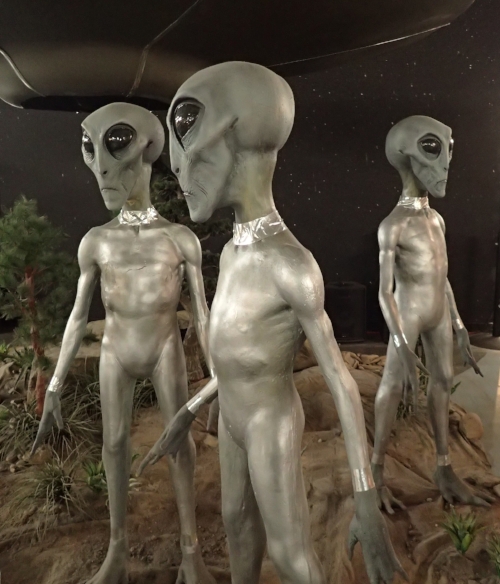
The International UFO Museum is near the major intersection in Roswell, which is a forlorn, rundown town. The International UFO Museum documents “The Roswell Incident.” The Museum is dedicated to the collection and preservation of materials and information in written, audio, and visual formats that are related to the 1947 Roswell Incident and other unexplained phenomena related to UFO research. I progress through the Roswell incident chronologically with newspaper articles, affidavits, pictures, re-enactments, statues, figures, and displays. While peacefully walking through the museum, I wind around a center display of a UFO and three alien figures, and am startled when creepy music starts to play and smoke fills the area. The UFO spins around and flashes its lights. This display, along with the strange figures reenacting the incident, adds to the hokey feel of the museum.
Overall, the displays make the story seem less believable. The people involved gave sworn statements 50 years after the incident, but the surreal figurines are in various comical poses. The gift shop sells car window stickers of alien families (which I purchase for my sister). Space-themed music plays throughout.
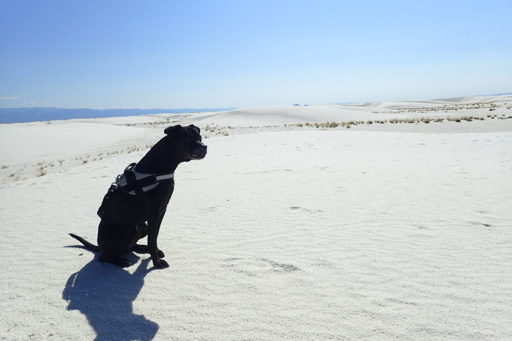
Nearby at the White Sands National Monument, the windblown sands and rolling dunes blanket an area of 115 square miles. It is the largest pure gypsum dune field in the world. It is gorgeous and white and blinding. My favorite sign states not to touch any strange objects, as the missile-testing site next door sometimes drops dangerous things.
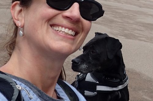
Surprisingly, the park allows dogs! Abby and I have a great time walking on the dunes, sliding down the slopes on our butts and paws, making side-by-side footprints in the sand, and sharing peanut butter crackers at the picnic tables. After a hearty lunch in the shadow of the dunes, Abby and I head for our Airbnb on a farm on the outskirts of Roswell.
The following morning, Abby and I speed towards Texas. In about an hour, we both stick our noses in the air and sniff. Then we sniff again. We look at each other quizzically. What is that noxious smell? It smells like a mix of Yellowstone’s sulfur, the Truth and Consequences hot springs steam, and a paper mill I once sniffed near Savannah, Georgia.
At our next stop, I google “What is that smell in west Texas?” Google tells me that oil production produces hydrogen sulfide. The state of Texas regulates the smell. The chemical itself is insidious and deadens the sense of smell, so you are unaware that the concentration is rising. Because of this, I wonder if officials periodically sniff the air and say, “Yeah, that’s about right”. People not from the region hold their noses, gag, and say, “What the hell?”
Noses numb, Abby and I head to Austin. We are excited to meet the second Kelly and start the city leg of the trip.